The sun will go partially dark this weekend for millions of people as a partial solar eclipse blocks out a chunk of our star.
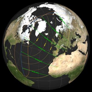
This astronomical phenomenon will fall on Saturday, March 29, 2025, and will be visible in 13 U.S. states, parts of northeastern Canada, and across much of western Europe and Africa. To help you find out if your location is in the path of the eclipse, NASA has now released a map revealing exactly how much of the sun will be eclipsed and where, and what time the eclipse begins in each region.
The East Coast of the U.S. and Canada will see the partial eclipse take over the largest portion of the sun, with 83% of the sun being blocked out in St John’s in Canada, 64% in Portland, Maine, 43% in Boston, and 22% in New York City, according to NASA. With the sun rising partially eclipsed in these locations, the moon will make our star appear to have a pair of ‘devil horns’ in the dawn light.

On the NASA map, the yellow lines show the extent of how much sun will appear to be blocked out from each location, and the green lines track the time in UTC at which the eclipse will hit its peak.
In St. John’s, Canada, for example, the partial eclipse will begin at 6:57 a.m. local time, peak at 7:52 a.m., and end at 8:51 a.m. In Boston, it will start at 6:31 a.m. local time, peak at 6:38 a.m. and end at 7:07 a.m., while in New York City, it will start at 6:44 a.m., peak at 6:46 a.m., and end at 7:04 a.m. In these spots, the moon will already be partially blocking the sun as the two celestial bodies rise above the horizon in the morning.
In London, meanwhile, where the eclipse will cover a maximum of 31% of the sun, the eclipse will start at 10:07 a.m. local time, peak at 11:03 a.m., and end at 12:00 p.m.
Related: How to watch Saturday’s sunrise ‘devil horn’ solar eclipse online for free
The orange loops on NASA’s map represent areas where the eclipse starts or ends at sunrise and sunset: the left side of the western loop (over the Americas) will see the eclipse end at sunrise, while the right side of this loop will see the eclipse start at sunrise. Meanwhile, the blue line bisecting these loops show where the eclipse will hit its maximum at sunrise or sunset.
Solar eclipses occur when the moon passes between the Earth and the sun, blocking out the light from our star and casting a shadow on the Earth’s surface. Unlike a total solar eclipse, where the sun is completely blocked in some areas, a partial eclipse results in the sun appearing as a crescent in the sky. This occurs because the alignment between the sun, moon, and Earth is not perfect.
How to watch the eclipse
According to timeanddate.com, over 800 million people will be able to catch at least some of the partial eclipse, although only 21 million will see the moon cover more than 50% of the sun. For everyone else, free live streams of the entire eclipse are being hosted on both sides of the Atlantic — Live Science has rounded up the best ones here.
Those hoping to catch a glimpse of the eclipse should never look at the sun directly without protection; even during a partial eclipse, the sun’s rays can cause serious eye damage. Observers should wear a pair of certified solar eclipse glasses at all times, or otherwise use a telescope or binoculars equipped with proper solar filters over the front lens.
“Do NOT look at the Sun through a camera lens, telescope, binoculars, or any other optical device while wearing eclipse glasses or using a handheld solar viewer — the concentrated solar rays will burn through the filter and cause serious eye injury,” NASA advises.
If you miss this partial eclipse, another partial eclipse will be visible from Australia, New Zealand, Antarctica, and the Pacific Ocean on September 21 this year.
On August 12, 2026, a total solar eclipse will be visible in Greenland, Iceland, Spain, Russia, and Portugal, while a partial eclipse will be visible in Europe, Africa, and North America.
Sun quiz: How well do you know our home star?


