
Table of Contents
[ad_1]
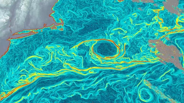
AI is turning weather satellites into real-time trackers of the ocean’s hidden currents.
Scientists have created a new way to measure ocean surface currents across large regions with far greater detail than previously possible. The method, known as GOFLOW (Geostationary Ocean Flow), uses deep learning to analyze thermal images captured by weather satellites already in orbit. Because it relies on existing satellite data, the approach delivers a major advance in ocean observation without the need for new hardware.
The study was led by Luc Lenain of UC San Diego’s Scripps Institution of Oceanography and Kaushik Srinivasan, a Scripps alumnus now at UCLA. Their work was published in Nature Geoscience. Co-authors Roy Barkan of Tel Aviv University and Nick Pizzo of the University of Rhode Island also studied at Scripps. Funding came from the Office of Naval Research, NASA and the European Research Council.
Why Ocean Currents Matter
Ocean currents are central to how Earth’s climate system works. They move heat around the planet, transport carbon between the atmosphere and the deep ocean, and circulate nutrients that support marine life. They also play an important role in practical applications such as search and rescue missions and tracking oil spills.
Despite their importance, measuring ocean currents over wide areas has been extremely difficult. Some satellites estimate currents indirectly by observing changes in sea surface height, but they typically revisit the same location only every 10 days or so — too infrequent to capture currents that can appear and disappear within hours. Ships and coastal radar systems can detect rapid changes, but only over relatively small regions.
The Challenge of Vertical Mixing
These limitations have left a major gap in observations at the scales where vertical mixing takes place — when surface waters move downward or deeper waters rise upward. The features that drive this mixing can be smaller than 10 kilometers (six miles) and can change within hours.
Vertical mixing is critical because it brings nutrients from deeper waters to the surface, supporting marine ecosystems. It also moves carbon dioxide from the surface into the ocean interior, where it can be stored for long periods. Without detailed observations, scientists have struggled to fully understand these processes.
Turning Satellite Images Into Current Maps
The idea behind GOFLOW emerged in 2023 when Lenain examined thermal images of the North Atlantic from the geostationary satellite GOES-East, which is primarily used for weather monitoring. These images are collected as often as every five minutes and show clouds as well as patterns of warm and cool water across the ocean surface.
Lenain noticed that major currents such as the Gulf Stream could be seen in these temperature patterns. This observation led to the idea of converting visible temperature changes into a way to measure ocean currents.
How AI Tracks Ocean Motion
To make this possible, the team trained a neural network to recognize how temperature patterns on the ocean surface shift and deform under the influence of currents. The system learned from high-resolution computer simulations of ocean circulation, which provided examples linking temperature patterns to water velocities.
By analyzing sequences of satellite images and tracking how these patterns move over time, the trained model can infer the currents responsible for the changes.
“Weather satellites have been observing the ocean surface for years,” said Lenain. “The breakthrough was learning how to turn that time-lapse into hourly maps of currents by tracking how temperature patterns bend, stretch and move from one hour to the next.”
Accuracy Confirmed With Real Data
The researchers tested GOFLOW by comparing its results with measurements collected by ships in the Gulf Stream region during 2023, as well as with traditional satellite methods based on ocean topography. The results showed strong agreement.
At the same time, GOFLOW revealed much finer detail, especially for smaller and faster-moving features such as eddies and boundary layers. Previous methods often smoothed these features into broad averages. With this improved resolution, scientists were able to detect key statistical signatures of small, intense currents that drive vertical mixing, which had previously been observed mainly in simulations.
“This opens a range of exciting possibilities in physical oceanography that, until now, were largely accessible only through simulations,” said Lenain. “Using GOFLOW, we can now measure key signatures of these small, intense currents using real observations rather than relying almost entirely on simulations. This opens the door to testing long-standing ideas about how the ocean takes up heat and carbon.”
No New Satellites Needed
Because GOFLOW uses data from existing geostationary satellites, it does not require launching new instruments into space. Over time, the method could be integrated into weather forecasts and climate models. It may also improve predictions by capturing rapidly changing currents that affect air–sea interactions, marine debris movement, and ocean ecosystems.
Limitations and Next Steps
Cloud cover remains a challenge, since clouds block the thermal imagery that GOFLOW depends on. The research team plans to combine additional types of satellite data to fill in these gaps and provide more continuous coverage.
Work is already underway to expand the method globally. The team has also made its data products and code publicly available, which will support further research and help explore new applications of the technology.
Reference: “An unprecedented view of ocean currents from geostationary satellites” by Luc Lenain, Kaushik Srinivasan, Roy Barkan and Nick Pizzo, 13 April 2026, Nature Geoscience.
DOI: 10.1038/s41561-026-01943-0
Never miss a breakthrough: Join the SciTechDaily newsletter.
Follow us on Google and Google News.
[ad_2]
Source link