
Table of Contents
Some landscapes photograph badly because they look better in person. They photograph strangely because the camera has no frame of reference. A white salt flat becomes a blank sheet. A forest of stone pillars looks composited. The top 7 places where nature looks almost unreal are not necessarily the most beautiful places on Earth, but they are the ones that make your brain run a quick double-check.
I have picked locations you can actually visit, with real access rules and seasons that change the show. Some are easy day trips. Others take a permit, a guide, or a long dirt road. All of them reward a little planning.
Planning these trips is less about inspiration and more about verification, a bit like the discipline behind maintainability sensors for coding agents: check access, season, permits, and whether the road is actually a road.
1. Salar de Uyuni, Bolivia
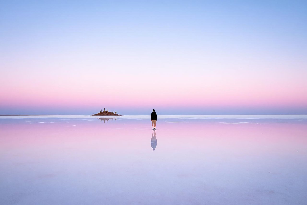
At 10,582 square kilometres, Bolivia’s Salar de Uyuni is the world’s largest salt flat. In the wet season, from roughly January to March, a thin layer of water turns it into a mirror. The horizon disappears. People look like they are standing in the sky.

The effect is strongest after rain but before the surface gets too deep for vehicles. Local guides know which routes are safe. In the dry season, the same plain becomes a cracked grid of white polygons, with Isla Incahuasi rising in the middle like a cactus-covered island. Both versions feel wrong in the best way.
Altitude is the catch. The salt flat sits at about 3,656 metres, so give yourself a day in Uyuni town before heading out. Pack sunglasses with real UV protection. The glare is brutal.
2. Zhangjiajie National Forest Park, China
More than 3,000 quartzite sandstone pillars rise from the forest in Hunan province. Fog does the heavy lifting. When clouds pour between the columns, the park looks like a matte painting with the edges left soft.
This is the landscape often linked to Avatar’s floating mountains, though the connection is more inspiration than exact filming location. The Bailong Elevator, a glass lift built into a cliff, climbs 326 metres in under two minutes. It is impressive and slightly surreal in its own right.
Go early. The park is popular with domestic tour groups, and the main viewpoints get crowded by mid-morning. A two-day pass lets you spread out the walks and wait for weather. Cloudy days are not a loss here. They are the point.
3. Socotra, Yemen
Socotra sits in the Indian Ocean off Yemen, and its isolation has produced a botanical world that looks borrowed from another planet. Dragon’s blood trees spread flat, umbrella-shaped crowns over rocky ground. Bottle trees swell like blown glass. About a third of the island’s plant species are found nowhere else.
Travel here is not casual. Yemen’s conflict and limited flights mean you should check government advisories, use a reputable local operator, and build in flexibility. When access is possible, places like Detwah Lagoon and the Diksam Plateau show why researchers treat the island as a living laboratory.
The landscape is fragile. Stick to tracks, carry out waste, and avoid buying coral or wildlife products. The weirdness is the draw, but the ecosystem is the reason it still exists.
4. Fly Geyser, Nevada
Fly Geyser was not supposed to exist. In 1964, a geothermal test well was drilled on private ranch land in the Black Rock Desert. The well was capped, failed, and began leaking mineral-rich water. Over decades, dissolved silica and calcium built up into colourful cones.
Thermophilic algae paint the runoff in reds, greens, and oranges. The result looks like a small volcano designed by a set decorator. It sits on Fly Ranch, which is private land, so you cannot simply drive up and walk around. Access is through organised tours and volunteer days with Friends of Black Rock High Rock.
That restriction is a good thing. The formations are delicate, and the surrounding desert is easy to damage. Book ahead, follow the guide, and leave the drone at home unless you have explicit permission.
5. Pamukkale, Turkey
Pamukkale means cotton castle in Turkish, and the name fits. Spring water loaded with calcium carbonate spills down a hillside and leaves behind white travertine terraces. The basins fill with warm, pale blue water. From a distance, the whole slope looks like a snowfield that forgot to melt.
The site sits above the Roman ruins of Hierapolis, so you can walk through ancient streets and then stand on geological formations in the same afternoon. The water temperature hovers around 35°C in places. Visitors must go barefoot on the travertines to protect the surface.
Arrive at opening time. Midday brings tour buses and harsh light. The lower terraces are usually quieter, and the contrast between white rock and blue water is easier to photograph before the sun gets high.
6. Antelope Canyon, Arizona
Antelope Canyon is a slot canyon cut into Navajo sandstone near Page, Arizona. Water and wind have smoothed the walls into curves that look carved by hand. At the right time of year, beams of sunlight drop through narrow openings and hit the sandy floor.
You cannot visit alone. The canyon sits on Navajo Nation land, and entry is by guided tour only. Upper Antelope is flatter and famous for light beams, usually from March to October. Lower Antelope involves ladders and tighter passages, with fewer crowds and more exercise.
Flash floods are a real risk. Tours close when storms threaten, even if the sky above Page looks clear. That is not overcaution. The canyon drains a much larger watershed. Book a licensed Navajo guide and treat the schedule as weather-dependent.
7. Deadvlei, Namibia
Deadvlei is a white clay pan in the Namib Desert, surrounded by some of the tallest sand dunes in the world. Camel thorn trees stand on the pan, dead for roughly 900 years. They are not petrified. The dry air has simply preserved them.
The name means dead marsh. The trees died after the river changed course, and the remaining skeletons contrast hard against rust-red dunes and a cobalt sky. It looks like a painting that has been left out in the sun.
Access is via Sossusvlei, usually with a 4×4 for the last sandy stretch. The park gate opens early, and the first hour of light is worth the alarm. Temperatures can climb fast, so carry more water than you think you need and turn back before the heat makes the decision for you.
Before you book, check these five things
These places look unreal because they depend on narrow conditions. A little verification saves a lot of disappointment.
- Access rules: Fly Geyser is private, Antelope Canyon requires a Navajo guide, and Socotra needs current travel advice and a local operator.
- Seasonal effects: Uyuni mirrors in the wet season, Antelope light beams in spring and summer, Zhangjiajie fog in wetter months.
- Permits and timed entry: Some parks sell out days ahead. Check official sites, not just tour resellers.
- Weather buffers: Build in an extra day for canyons and salt flats. Floods, wind, and cloud can cancel the exact scene you came for.
- Gear that actually helps: Polarised sunglasses for salt flats, dust protection for camera gear, sturdy shoes for travertine and slot canyons, and two litres of water per person for desert walks.
The unreal part is often just a narrow window of light, water, or fog. Miss the window and you get a very real, very ordinary landscape. Hit it, and you will spend the rest of the trip trying to convince people the photos are not edited.


