
Table of Contents
Environmental change rarely stays contained. A river diverted for cotton, a grassland stripped of its sod, or a volcano that loses its summit can set off consequences that reach far beyond the first damaged hectare. The seven cases below are not a ranking of the worst or the fastest. They are the top 7 environmental changes that transformed entire regions, measured by how thoroughly they redrew maps, livelihoods, and ecosystems. Some unfolded over decades. Others took a single morning.
The Aral Sea: A Sea Turned to Salt and Dust
In the 1960s, Soviet planners diverted the Amu Darya and Syr Darya rivers into canals to irrigate cotton across Central Asia. The Aral Sea, once the fourth-largest lake in the world, had no other major inflow. It began to fall.
What the water left behind
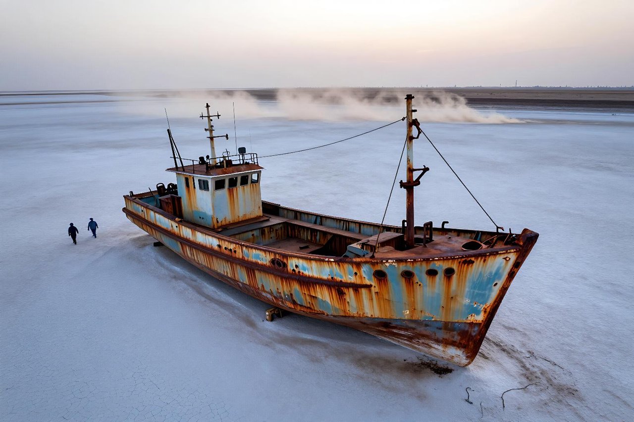
By the late 2000s, the sea had lost roughly 90% of its volume. The port of Moynaq sits more than 100 kilometres from the current shoreline. Fishing fleets rust on dry ground. A cannery that once processed thousands of tonnes of fish each year closed. The exposed seabed became a source of salt and pesticide-laden dust, blowing across Uzbekistan and Kazakhstan. Rates of respiratory illness and kidney disease rose in nearby communities.
- More than 40,000 square kilometres of former seabed became salt flats and desert.
- Native fish species disappeared from the main sea; commercial catches collapsed by the 1980s.
- The Kokaral Dam, completed in 2005, helped restore part of the North Aral Sea and its fishery.
The Aral case shows how an agricultural decision in Moscow changed the climate, economy, and public health of a region hundreds of kilometres away.

The Dust Bowl: How Ploughing Broke a Grassland
The southern Great Plains evolved with deep-rooted grasses that held soil through drought. Wheat prices during World War I encouraged farmers to plough millions of acres. Then came the dry years of the 1930s.
A decade of black blizzards
On 14 April 1935, a black blizzard carried an estimated 300 million tonnes of topsoil from the Plains toward the East Coast. It was one storm in a decade of them. Wind erosion damaged about 100 million acres across the region. Families abandoned farms; some 2.5 million people left the Plains states during the 1930s, many for California. The federal government responded with the Soil Conservation Service in 1935, shelterbelts, contour ploughing, and grassland restoration.
The Dust Bowl turned a wheat frontier into a landscape of migration, relief camps, and new soil laws. Its lessons still shape farm policy and drought planning.
China’s Loess Plateau: Restoring a Worn-Out Landscape
The Loess Plateau covers roughly 640,000 square kilometres in northern China. Its powdery soils are fertile but erode fast. Centuries of clearing and grazing sent enormous sediment loads into the Yellow River, which carries its name from that mud.
Beginning in the 1990s, the Loess Plateau Watershed Rehabilitation Project combined terracing, tree and grass planting, grazing bans, and sediment dams. The project eventually treated about 35,000 square kilometres. In some catchments, sediment reaching the Yellow River fell sharply, with some estimates putting reductions above 80%. Farmers who gave up slope land received flatter terraces and orchard plots. Grain output rose in many project areas even as erosion fell.
This is one of the clearest examples of a deliberate environmental change reversing regional decline. The plateau is not restored to a pristine past; it is a working landscape designed to hold soil and water.
The Draining of the Fens: Wetland Into Farmland
Before the 17th century, the Fens of eastern England were a maze of reed beds, shallow meres, and seasonal floods. Dutch engineer Cornelius Vermuyden led drainage works that cut new channels and installed wind-powered pumps. The result was some of England’s richest farmland.
The transformation came with a slow cost. Peat soils exposed to air oxidise and shrink. Parts of the Fens have sunk by several metres, and pumping must continue to keep them dry. The drained peat releases carbon dioxide, and the region now faces the double challenge of sea-level rise and soil loss. Farming, conservation, and flood management compete for the same flat land.
The Fens show that environmental change can create wealth and vulnerability in the same stroke.
Lake Chad: A Shrinking Water Source in a Crowded Region
Lake Chad once covered around 25,000 square kilometres. By the 2010s, its open water had shrunk to roughly a tenth of that in dry years, though the lake’s seasonal wetlands still expand and contract. Drought, rising irrigation withdrawals, and population growth all played a role.
Fishing communities lost their catch. Herders moved livestock farther south. Farmers pushed into exposed lakebed. The pressure helped fuel local conflict and displacement, especially around the Lake Chad Basin, where Nigeria, Niger, Chad, and Cameroon meet. Not every problem traces back to the lake alone, but the shrinking water set the stage for competition over fertile land.
There is no single fix. Recharge varies with rainfall, and large-scale water transfers remain expensive and politically fraught.
Mount St. Helens: A Landscape Reset by Eruption
On 18 May 1980, Mount St. Helens in Washington State erupted with a lateral blast that removed about 400 metres from its summit. The blast flattened forests across roughly 230 square miles. Fifty-seven people died. Ash fell across 11 states.
Ecologists had a rare chance to watch succession from close range. Lupines and other nitrogen-fixing plants colonised the pumice. Elk returned. Dead trees fell into Spirit Lake, changing its chemistry. The U.S. Forest Service and volunteers replanted parts of the blast zone, while other areas were left to recover on their own.
The eruption transformed a mountain, a forest, a river system, and a local economy. Tourism and scientific study grew around the volcano; the landscape remains a living laboratory more than four decades later.
The Sahel: Farmer-Managed Re-greening
The Sahel suffered devastating droughts in the late 1960s and early 1980s. Rainfall dropped, crops failed, and famine killed tens of thousands. Images of cracked earth and dying cattle shaped how the world saw the region.
In parts of Niger, farmers began protecting naturally regenerating trees in their fields rather than clearing them. This practice, known as farmer-managed natural regeneration, spread across millions of hectares. Trees such as Faidherbia albida dropped leaves that enriched soil, provided fodder, and shaded crops. Yields improved in many areas, and rural incomes rose. The change did not erase drought or conflict, and not every project succeeded. Still, it altered the trajectory of farmland across a broad swath of West Africa.
The Sahel case is a reminder that environmental change is not always a story of loss. Sometimes it begins with a farmer deciding to leave a useful tree standing.


